The Icefields Parkway
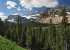
One of the most spectacular mountain roads in the world, the Icefields Parkway follows river valleys just east of the Continental Divide, running 140 miles from Lake Louise northwest to Jasper. The parkway is part of what makes visiting the Canadian Rockies so worthwhile, even for casual tourists, as incredible scenery is easily visible right from the road for most of its length, along with a great deal of wildlife. Most of the parkway is in Banff National Park, with this sceneset focusing on the area from Lake Louise to the Icefields Visitors' Centre across from Athabasca Glacier. Be sure to also view the Columbia Icefield Region subset, since it also includes parts of the Icefields Parkway.
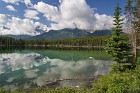 1 Herbert Lake Reflections When we started out on the Icefields Parkway, I was excited about the famous lakes I wanted to see: Peyto, Bow and the other "big name" bodies of water known for their beauty. I was surprised when, less than a mile up the road, I spotted this scene out my car window. Herbert Lake? Never heard of it. The small, arrowhead-shaped lake turned out to be one of my favorites of the region. Enhancing it on this morning drive was a nice variety of pretty clouds, the result of clearing bad weather from the previous day. |
 2 Herbert Lake and the Bow Range A wider version of the preceding image, showing most of Herbert Lake. Behind it, tucked under the rising clouds, Mt. Niblock and Mt. Whyte; beyond them, the peaks of the Bow Range, better known as the backdrops of Lake Louise and Moraine Lake. |
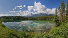
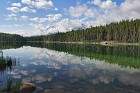 3 Herbert Mirror This is also Herbert Lake, and was taken at around the same time as the preceding images, but appears quite different from them simply due to a change of angle. The water was remarkably clear and still despite the image having been taken several hours after sunrise. |
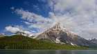
 4 A Sliver of Hector Lake Hector Lake is substantially larger than its similarly-named neighbor to the south, Herbert Lake, but appears small in this image because of distance. Rising directly behind it is Pulpit Peak. Beyond the mountains lies the Waputik Icefield, a smaller field with an area of roughly 15 square miles. |
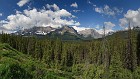
 5 The Icefields Parkway The parkway is just mile after mile of amazing scenery: soaring, snow-covered mountains, sparking impossibly-blue lakes, and thick, green confier forests. Plenty of wildlife as well, if you're a bit lucky. |
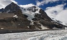
 6 Crowfoot Glacier and Mountain Crowfoot Glacier was named by early explorers for its appearance: it had three long "toes" and thus resembled a bird's foot. Like most glaciers in the Rockies, however, it has been receding for many years, and the lowest toe disappeared in the middle of the twentieth century, leaving the two that remain visible near the upper-center of this shot. The summit of the mountain of the same name is just above and to the right of the glacier. The smaller mount on the left is Bow Peak. You can see a small part of the southern end of Bow Lake here as well. |
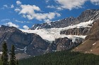 7 Crowfoot Glacier A closer shot of Crowfoot Glacier, clearly showing the two remaining "toes" and the stub near the bottom where the third one was. This glacier was once part of the Wapta Icefield, but became separated from it several decades ago. |
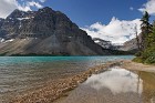 8 Bow Shore Bow Lake taken from the slightly-flooded shoreline. The large peak is part of Crowfoot Mountain. Bow Glacier, a small tongue of the large Wapta Icefield, can be seen on the right; it's a bit hard to spot as it blends into the large clouds just above it. |
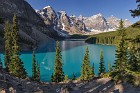
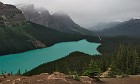
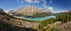
 9 The Incomparable Peyto Lake Peyto Lake is perhaps the most famous of all the lakes in the Canadian Rockies, and it's easy to see why. The natural beauty of the area is enhanced by the fact that the viewpoint is nearly 600 feet higher than the lake, creating a truly breathtaking view that rivals anything I've seen elsewhere in North America. The lake is a turquoise color from rock flour constantly flowing into it from Peyto Glacier to its south, seen here on the far left edge of the panorama. The prominent mountain that forms the backdrop is Caldron Peak, illustrating its steepness with numerous avalanche chutes. |
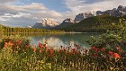
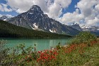 10 Majestic Mount Chephren The distinctive peak of Mount Chephren rises above Upper Waterfowl Lake, while numerous red Indian paintbrush plants provide a nice bit of color balance. Chephren Lake is located beyond the triangle-shaped, forested slope in the middle ground. |
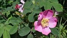 11 Rosa Acicularis The wild rose is the provincial flower of Alberta and is found all over the Canadian Rockies. |
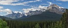
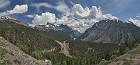 12 Big Bend, Big Hill Given the terrain through which it winds, most of the Icefields Parkway is remarkably "well behaved": it's pretty flat, and there are few treacherous areas or steep climbs. One notable exception is a section near the far northern part of Banff National Park, where the road climbs some 700 feet in a short distance. To make this possible, the road bends back on itself in a hairpin turn called the Big Bend, which rises up the uninspiringly-named Big Hill. The names are dull, but the view is not. This panorama looks south after climbing the hill, showing the parkway snaking far below. This is a classic "U-shaped" glacially-carved valley. I believe the large sloping mountain on the right is Mount Saskatchewan. |
 13 Golden Peyto Taken on a mostly cloudy day when the sun broke through near sunset and lit up the rocks just below the viewpoint, this image shows Peyto in a very different mood from the traditional "postcard shot". |
 14 Beautiful Evening at Upper Waterfowl Lake It was a really beautiful evening when we went for a drive down the Icefields Parkway, this stop at Upper Waterfowl Lake. The sun sets very late in northern latitudes in the summer; this picture was taken at 9 pm and the sun was only just starting to set. |
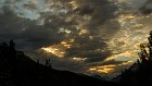 15 Brooding Clouds roll in as the sun is setting over the Continental Divide. |
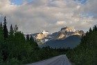 16 Quiet Parkway One of the advantages of being an early-rising photographer is having even popular roads like the Icefields Parkway to oneself. :) |
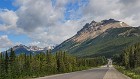
 17 Early Light Near Saskatchewan River Crossing Morning light hits the mountains near Saskatchewan River Crossing, where the Icefields Parkway meets the David Thompson Highway; the latter leads east to Red Deer, Alberta. |
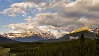
 18 Blowing Off The mountains of the Continental Divide "wring out" moisture from air that passes over them, creating clouds that blow off the tops of the peaks. This is especially noticeable in the morning, an hour or two after sunrise. |
 19 Chephren, Shrouded Mount Chephren looked especially pretty this morning as low clouds burned off in the rising sun. |
 20 Socked In If you only had one opportunity to visit Peyto Lake and it looked like this, you'd probably be pretty disappointed. But since I was able to come to this spot several times, I liked the less typical, moody feel on this cold and rainy day. Actually, not just rainy -- we had wet snowflakes on our car's windshield as we neared this viewpoint, despite the date in early July! |
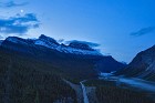 21 Moon Over Cirrus Mountain The beautiful view from the top of Big Hill is looking rather blue in this 4:53 am image, as the crescent moon rises over Cirrus Mountain. So, why was I up on top of Big Hill at this hour, early even for a photographer? I was in the middle of driving 4 hours in the dark from Kootenay National Park all the way back to Jasper National Park to try to catch the sunrise I hadn't been able to get when we stayed in Jasper (due to the weather). See near the end of that sceneset for the whole crazy story. :) |
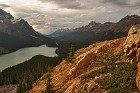
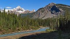
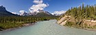 22 The River Wide The North Saskatchewan widens dramatically as its banks spread near Saskatchewan River Crossing, where it meets the Howse and Mistaya rivers. |
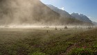 23 Steam This almost looks like it was taken in a geothermal area, but it is just morning fog burning off from a field adjacent to the Icefields Parkway, near the border between Banff and Jasper National Parks. |
 24 Sky Blue The sky and the river are nearly the same color in this simple landscape of the North Saskatchewan River, taken south of Big Bend. |
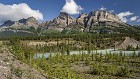 25 Mount Wilson Mount Wilson is the dominant peak near Saskatchewan River Crossing. Weather has eroded deep gullies down its sides, giving it almost a pleated appearance. This image was taken from an embankment just off the Parkway. |
 26 Waterfowl on the Lake It seemed fitting that I was able to capture an image of a duck swimming on Upper Waterfowl Lake on this crisp morning. |
 27 Peyto Revisited As we were leaving Banff National Park, I couldn't resist stopping one more time at the Peyto Lake overlook. This time the water was nearly perfectly still and provided a nice reflection of Mount Patterson (right center). If you look beyond the far right edge of the lake, you can see for many miles down the path of the Icefields Parkway. I found out while doing some research that the lake is named after explorer Bill Peyto, and is pronounced "peeh-toe". I've been saying "pay-toe" for so long that I have a hard time saying it the right way! |
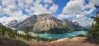
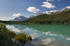
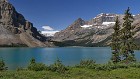 28 Bow Lake and Glacier A different view of Bow Glacier and part of the lake of the same name, taken from the middle of its eastern edge. Center-right, Mount Jimmy Simpson, named after an early 20th century Rockies explorer and guide. |
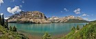 29 Bow Lake Panorama A wider view of Bow Lake's crystal blue glacial waters. Part of Crowfoot Glacier can be seen far left. |
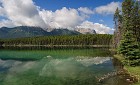 30 Herbert Lake - Another Perspective I close this section of Scenes from the Canadian Rockies where I began -- the gorgeous Herbert Lake, at the southern tip of the Icefields Parkway. |