Scenes from a Day at Yosemite (2003)
Join me on a pleasant day trip in late summer to one of the most beautiful places on earth. See the Yosemite Valley and areas nearby, including a number of breathtaking panoramas taken from a variety of idyllic locations.
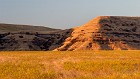 1 Sunrise on the Foothills My day of adventure at Yosemite began with the departure from my hotel in San Jose at about 5:30 am. The first part of the trip was on the highways between San Jose and Stockton, California, where I was continuously amazed at the endless miles of heavy traffic heading towards the Bay Area at such an early hour, even almost 50 miles from San Francisco. As the dawn broke and the sky lightened, I waited for the sun to peek out over the distant Sierra Nevada. When it did, it bathed the land in a wash of gold, and I had to find something interesting around to capture the light. These interesting foothills fit the bill. |
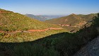 2 Climbing the Sierras The drive from the Bay Area of California to Yosemite Valley takes about four and a half hours, and is an excellent study in the contrasts inherent in California's landscape. Most of the first two-thirds of the drive is through California's fertile -- and very flat! -- central valley, where I saw endless groves of fruit and nut trees. Then, seemingly out of nowhere, you hit the mountains, and the road begins to curve and wind up the side of the slopes. This is a view back towards the west, with the rising sun behind me; I believe that is Don Pedro Lake in the background (see the final image in this SceneSet for more on the lake.) |
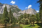
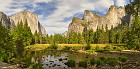
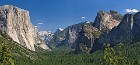 3 Yosemite Valley Tunnel View Panorama When I arrived at Yosemite, all excited, I -- had to turn around and leave the park to get gas, because the only gas station in the area of the park I was visiting was shut down for repairs. :) When I returned, my first destination was Glacier Point, reached at the end of a remarkable highway that winds its way through the southwestern part of the park. To get to Glacier Point from Yosemite Valley, you pass through a famous tunnel, at the end of which is an even more famous view of the Yosemite Valley: the aptly-named Tunnel View. As I pulled into the parking lot along the road to take in this view, I knew I was in for something special, but that did not prepare for the sheer grandeur, the incredible beauty and awesome scale that is the Yosemite Valley. I literally stood there for several minutes, transfixed at the view; it quite honestly doesn't seem like it can be real. The photograph won't give you this feeling; you have to visit for yourself. On the left, the massif of El Capitan rises above the valley; on the right you can see wisps of Bridal Veil Falls at low volume; and in the background, center, the distinctive Half Dome. |
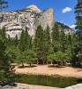
 4 Green and Gray I reached Glacier Point late in the morning, and immediately learned exactly why it is near the top of the list of 'must-see' places at Yosemite. At an elevation of 7,214 feet, it puts you over half a mile above the valley floor, and offers tremendous views in several directions. One of the first images I took was this two-image vertical 'mini-panorama' looking deep into the narrow part of Yosemite Valley, framed by gray granite and green conifers in the foreground, and the massif of Half Dome on the right side above. |
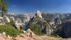
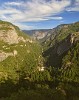
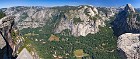 5 The Breadth and Depth of Yosemite Valley This panorama, comprised of 12 images in a 6x2 array, is my feeble attempt to capture the incredible view of the Yosemite Valley from Glacier Point. Once again, it doesn't really do justice to how it feels to actually be standing at the edge of the viewpoint looking down over 3,000 feet into the amazing valley below. Despite the wide view, this only covers about half of Yosemite Valley, roughly the portion east of Yosemite Village. Along the walls across from the valley, you can see Yosemite Falls left-center (barely a trickle in September), Yosemite Point, North Dome, Basket Dome, the Royal Arches and Washington Column. The valley floor is dominated by evergreen forest and the serpentine Merced River, interspersed with various campgrounds and national park buildings. On the far right, Yosemite Valley turns northeast and narrows into Tenaya Canyon; on one side is Mount Watkins, and on the other, the unmistakable Half Dome. |
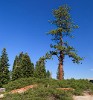 6 Majestic Tree at Glacier Point It's a testament to the power and tenacity of nature that trees can grow and flourish at these high altitudes. That's especially true given the many feet of snow that the Sierra Nevada receives every year -- there are winters when this tree must be over half-way buried in snow, which may not melt entirely until late June or even into July. The sky on this September day was a brilliant shade of blue, framing this tree. It wasn't the tallest tree but it was the most regally placed, and could probably lay claim to the title of "King of the Mountain" -- or at least, King of Glacier Point! |
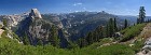 7 South of the Valley Yosemite National Park is quite large, covering an area of approximately 1,200 square miles. Most visitors to Yosemite, however, never venture out of the valley, or if they do, never go far. Unfortunately, due to the very limited time I had for this spur-of-the-moment trip, this applied to myself as well. When I first processed this SceneSet, I entitled this image "South of the Valley", and I've maintained that name for historical reasons. But I subsequently discovered that most of what you're seeing here is actually east of the main part of Yosemite Valley, not south of it. The termination of Yosemite Valley can be seen at far left, beyond Half Dome. In the center is much of Little Yosemite Valley, including the monolith known as Liberty Cap, and next to it, Nevada Fall. The tall dome-like peak in the middle distance center-right is Mount Starr King. To its left, on the horizon, is the Clark Range, named for Galen Clark, an early explorer of the Sierras who served as guardian of Yosemite National Park for 24 years. I believe the summits visible here are, from left to right: Mount Clark, Gray Peak and Red Peak. Merced Peak caps off the Clark Range, but in this view is hidden behind Starr King. |
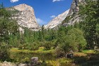
 8 A Peaceful View Another beautiful, serene view from Glacier Point. This image is similar to the previous one, but with a narrower view that focuses on the "twin" vales -- Yosemite Valley on the left and Little Yosemite Valley on the right -- that are found on either side of Half Dome. You can see Nevada Fall and Vernal Fall in Little Yosemite, large cascades on the Merced River. Left of Nevada Fall is Liberty Cap, and left of that, Mt. Broderick (which is only slightly shorter than Liberty Cap, even though the difference looks significant from this angle). |
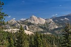 9 The Other Side of the Domes This image was captured somewhere on the Glacier Point Road, showing several glacially-rounded domes in the upper elevations of the Sierra Nevada. |
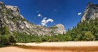
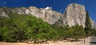 10 The Valley Floor After spending about an hour at Glacier Point -- and wishing I could linger longer, and perhaps take a hike to nearby Taft Point -- I drove back down Glacier Point Road and into Yosemite Valley. I had planned to first drive right to the Visitor Center at the heart of the valley, but I didn't make it without first stopping to take this panorama. The deep blue skies, wispy clouds, colorful rock walls of El Capitan and the trees in the foreground were too much to resist! |
 11 Over the Merced The Merced River winds its way through Yosemite Valley, here at a relatively low late-summer level. Its brown coloring contrasts with Yosemite's classic greens and grays, and the ever-present blue sky of summer. On the right side you can see Yosemite Falls -- or rather, you can see the location where you would see Yosemite Falls if you came to Yosemite in the spring or early summer. :) By September, the park's waterfalls have dried up or been reduced to mere trickles. |
 12 The Royal Arches and North Dome -- Scene from a Bridge Several interesting bridges span the Merced River along the Yosemite Valley, many themselves made of gray granite similar to the formations that tower over them. (Part of this bridge is visible here at lower right.) In the background here you can see three more Yosemite landmarks: the Royal Arches (natural arcs in the stone wall on the left) and above them, the rounded form of North Dome and the angled spire of Washington Column. |
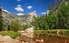
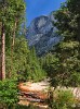 13 Framed by Trees A "head on" view of Half Dome framed by evergreens, with the dry banks of Tenaya Creek in the foreground. |
 14 Mirror Lake Reflections Mirror Lake is one of the most popular locations for viewing scenery in the Yosemite Valley, because it is beautiful and peaceful, and while easy to access, is far enough away to keep down the crowds. Like everything else in Yosemite associated with water, it is highly seasonal. In the spring, when water levels in the Yosemite Valley run very high, Tenaya Creek is a torrent and Mirror Lake is fairly large. As spring fades to summer, the rivers drop and the lake slowly shrinks; by the end of the summer, most of the water is gone, and there's just a small remnant as seen in this 3x2 panorama. Mirror Lake is slowly filling in with river-deposited sediment; geologists say that all of Yosemite Valley was once a lake that was filled in over hundreds of years by river sediments in this same manner. For many years the National Park Service dredged to stop the lake from filling in, but consistent with the emphasis in recent decades of preserving natural processes in national parks, this intervention has been discontinued. Thus, one day Mirror Lake will be Mirror Meadow, a name that will seem strange to those who don't know its history... |
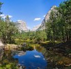
 15 Tenaya Canyon Vista Taken along the shore of Tenaya Creek, near Mirror Lake. The low water levels exposed some very interesting rock formations, sandbars and vegetation, with the walls of Tenaya Canyon forming a backdrop to the scene. I believe the peak in the center is Mount Watkins. |
 16 A Day at the Beach It's not really a beach; it's a nearly dry riverbed. But it sure looks like one! |
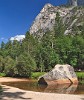 17 Tenaya Rock I loved the shape and coloring of this large boulder in Tenaya Creek; it's actually somewhat famous, and appears in a lot of photographs of the area. Looking up, the little hump on the canyon wall top center is called Ahwiyah Point, where there was a large rockfall in 2009, estimated by the National Park Service at 115,000 tons of stone and debris. Rockfalls are a natural part of the local geology and occur every few years in Yosemite. |
 18 All the Elements Granite towers, evergreen trees, lush meadow, flowing water and blue skies... all the elements of a pleasant day in the Yosemite Valley. |
 19 Lazy Afternoon at the River While mid-September is technically still summer, in many parts of the United States it is actually well on the way to being fall. In California, though, it really is still summer, and this warm day was proof. There wasn't much water in the Merced River, but it was enough for some younger visitors to the Valley to take a quick dip to cool off from the afternoon sun. |
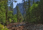
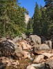
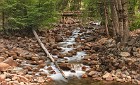
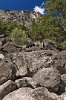 20 Wall of Rock After completing my look around the Yosemite Valley and the short hike to and from Mirror Lake, I decided I still had enough time for one more hike. I set out from the "Happy Isles" location near the end of the Yosemite Valley loop road, along the Mist Trail that goes up to Vernal Fall and Nevada Fall. It also connects to other trails that lead deep into the heart of Yosemite's backcountry. The trail was wonderful to walk along, as it was lined by huge rocks and boulders as you see here. Looking up at the top of the valley, it just seemed like a wall of rock from bottom to top. (This is actually a four-image vertical panorama, which was a bit tricky to properly process.) |
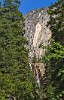 21 V is for Vernal Vernal Fall, like the other Yosemite falls, is much more impressive in the spring and early summer than it is in September. But it was still worth the hike. Unfortunately, I didn't have enough time to go all the way up to Nevada Fall. I like the way the trees form a V-shaped frame of the falls here. This is another slightly tricky stitched vertical panorama (I was really on a panorama kick at this stage of my photographic career!) |
 22 Merced River Cascades A trickle of the Merced River cascades down the steep mountainside near Vernal Fall. |
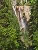 23 Ribbons at Vernal Fall Most people consider the grand waterfalls of Yosemite to be at their powerful best in May and June, when runoff from the melting of many feet of snow in the High Sierra turns rivers into torrents. You can get a sense of this just from the name of Vernal Fall -- "vernal" means "related to spring". But when the water level is low, the falls take on a more graceful beauty. Here, trickles of water coming over Vernal Fall blow and sway like ribbons in the wind. |
 24 On the Rocks By the time I got up to Vernal Fall, it was getting towards mid-afternoon. Did I mention that I did this trip on the day my flight back home left San Jose at around 9 pm? With about a four-hour drive still ahead of me, I had to high-tail it back to the car if I wanted to leave myself time for a few more shots before leaving Yosemite! I used a few minutes of that time to snap this image of the Merced gracefully tumbling its way across colorful rocks towards the valley floor. |
 25 Picket Fence From this position near the middle of Yosemite Valley, a row of pine trees makes it look almost as if the valley has been fenced in to protect its treasures. Behind the "fence" we see the Royal Arches, North Dome and Washington Column on the left, and Half Dome on the right. |
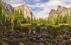
 26 Yosemite Valley View Panorama My last stop before saying a reluctant farewell to Yosemite was at the picturesque location known as Valley View -- for obvious reasons. This spot is a bit tricky to find, because the view is looking back towards the valley as you are leaving on the loop road. If you aren't looking for it, you'll drive right past it, which would be a shame! By this time the sun was starting to get fairly low in the horizon, which provided me with golden light and deeper shadows, and the sky had begun to fill in with wispy clouds, making for a pleasant conclusion to the day. Being nearer the entrance to Yosemite Valley, you can see some different features here than in many of the other images of this SceneSet -- on the left, the famous monolith known as El Capitan; on the right, the Cathedral Rocks, Bridal Veil Falls, and the Leaning Tower. |
 27 Another Valley View The low water levels of the Merced River allowed me to take this slightly different shot from Valley View. (In the spring, not only would the rocks and the clumps of grasses not be visible, I'd probably be at risk of being swept away if I were standing here!) |
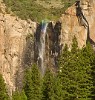 28 Rainbow Wisps at Bridal Veil Falls With a height of about 900 feet, Bridal Veil Falls (also called Bridalveil Falls) is one of the star attractions of Yosemite. The fall is fed by Bridal Veil Creek, which flows through a classic glacial hanging valley before plunging to the floor of Yosemite Valley, where its waters join the Merced River. Hanging valleys are created when glaciers erode rock at different rates, resulting in tributary valleys with higher floors than the valleys to which they connect. At the time I visited, the flow of this fall was rather limited due to the dry California summer. This allowed the high-altitude winds to blow the water around, creating wisps that cast partial rainbow colors in the late afternoon light. In the spring, the fall is a raging monster; the dark markings on the canyon wall show approximately the extent of the wall that gets wet during high flow. |
 29 Parting Shot A final view of the entrance to Yosemite Valley, with the Merced River snaking its way east out of the Sierras, as I climbed out of the canyon and headed back towards the mundane. A day I will never forget... |
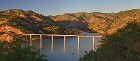 30 Sunset on Don Pedro Lake Located in the foothills of the Sierra Nevada east of Modesto, California, Don Pedro Lake is actually a large reservoir -- in fact, it's the sixth-largest body of water in the state. It was created by a dam built on the Tuolumne River in 1971 (which replaced a much older dam, now underwater.) The reservoir is used for irrigation, electricity generation and recreation. I passed by this overlook of Don Pedro on my drive back to San Jose, as the sun was setting. I really liked the way the sunlight carved shadows into the hills, and I found the bridge pretty impressive as well. The boat in the foreground should give you a sense of how large both the reservoir and bridge are -- and this is only part of the reservoir. |